


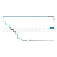
Voting District 21240, Kern County, California
About
Outline

Summary
| Unique Area Identifier | 531568 |
| Name | Voting District 21240 |
| County | Kern County |
| State | California |
| Area (square miles) | 61.98 |
| Land Area (square miles) | 61.98 |
| Water Area (square miles) | 0.00 |
| % of Land Area | 100.00 |
| % of Water Area | 0.00 |
| Latitude of the Internal Point | 35.32208500 |
| Longtitude of the Internal Point | -117.74294640 |
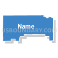
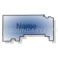
Maps


Graphs
Select a template below for downloading or customizing gragh for Voting District 21240, Kern County, California


Neighbors
Neighoring Voting District (by Name) Neighboring Voting District on the Map
- Voting District 10370, San Bernardino County, CA
- Voting District 10490, San Bernardino County, CA
- Voting District 10495, San Bernardino County, CA
- Voting District 10670, Kern County, CA
- Voting District 10705, Kern County, CA
- Voting District 10710, Kern County, CA
- Voting District 20585, Kern County, CA
- Voting District 20600, Kern County, CA
- Voting District 21245, Kern County, CA
- Voting District 21250, Kern County, CA
- Voting District 21255, Kern County, CA
Top 10 Neighboring County Subdivision (by Population) Neighboring County Subdivision on the Map
Top 10 Neighboring Place (by Population) Neighboring Place on the Map
Top 10 Neighboring Unified School District (by Population) Neighboring Unified School District on the Map
- Sierra Sands Unified School District, CA (35,267)
- Barstow Unified School District, CA (33,588)
- Mojave Unified School District, CA (18,880)